

By Jeff Shepard
Real-time asset tracking and condition monitoring are essential in agricultural operations like livestock management, cold chain warehousing for foods and pharmaceuticals, managing fleets of vehicles, and Industry 4.0 flexible production operations. It is a complex process involving multiple sensors to monitor environmental conditions. It stresses that the asset is subjected to multi-constellation global navigation satellite system (GNSS) capability including GPS, Galileo, Glonass, BeiDou, and QZSS to ensure accurate location information. Additionally, multi-connectivity solutions provide timely communication of the location and condition of the asset regardless of the surrounding environment including connectivity to the cloud to support centralized monitoring. Also, it needs to be energy efficient to minimize the need for battery power, and the system must be secure and safe from hacking.


Designing an asset tracking and condition monitoring system is a complex multi-disciplinary activity that consumes many resources and takes significant time. In addition to the complexities associated with the hardware design, the data needs to be securely connected to the cloud and mobile devices to make the wealth of information generated available in actionable formats.
Instead of starting with a blank page when designing asset tracking systems, designers can turn to development kits and reference designs that simplify prototyping, testing, and evaluating advanced asset tracking applications. This article will review the GNSS, sensors, connectivity, and other considerations when developing asset tracking and condition monitoring systems and then presents a comprehensive dev kit from STMicroelectronics that includes multiple printed circuit boards for various types of sensors, GNSS positioning, and communications capabilities. The kit also includes battery and advanced power management to maximize battery life, software, and firmware libraries, and application development tools.
Where in the world is the asset?
The first step in tracking assets is gathering current location information using the national marine electronics association (NMEA) data format. NMEA is the standard used by all GPS makers to ensure interoperability. The standard NMEA message format is referred to as a sentence. NMEA defines several sentences to provide various types of information, including:
- GGA – global positioning system fix data including 3D coordinates, status, the number of satellites used, and other data
- GSA – dilution of precision (DOP) and active satellites
- GST – position error statistics
- GSV – number of satellites in view and the pseudo-random noise (PRN) number, elevation, azimuth, and signal-to-noise ratio for each satellite
- RMC – position, velocity, and time
- ZDA – UTC day, month, and year, and local time zone offset
Using NMEA simplifies location software development since a common interface can be used for various types of GPS receivers, and specific data sets can be easily accessed using the corresponding sentence.
How can accuracy be improved?
Raw GNSS data provides only limited location accuracy. Tools are available to improve the location estimate, including the Differential Global Positioning System (DGPS) service that provides correction signals to GPS navigation equipment on board ships. DGPS uses the Radio Technical Commission for Maritime (RTCM) protocol to provide enhanced location data. In addition, satellite-based augmentation systems (SBASs) are available to improve the accuracy of position information, including the Wide Area Augmentation System (WAAS) in America, the European Geostationary Navigation Overlay System (EGNOS), Multi-functional Satellite Augmentation System (MSAS) in Asia, and GPS-aided GEO augmented navigation (GAGAN), a regional SBAS in India (Figure 1).
What’s the asset’s condition?
In many cases, knowing the location of the asset is only one piece of the puzzle. It can be important to collect information about the asset’s condition, including its physical status and whether it is or has been moving or stationary. Depending on the need, various sensors can be deployed, including:
- Temperature sensor with an operating range of -40°C to +125°C, high accuracy, and calibration that is National Institute of Standards and Technology (NIST) traceable and verified as required by the IATF 16949:2016 standard.
- Pressure sensor – a compact and rugged microelectromechanical system (MEMS) piezoresistive absolute sensor can be used as a digital output barometer with a 260 to 1260 hectoPascals (hPa), also called millibars, absolute pressure range. It needs to be highly accurate and include temperature compensation.
- Humidity sensor with an operating temperature range of -40°C to +120°C and a humidity measurement range of 0 to 100% relative humidity (rH). It should be temperature compensated with an accuracy of ±3.5% rH from 20 to 80% rH.
- Inertial measurement unit (IMU) including a MEMS-based 3D accelerometer and 3D gyroscope to determine if the asset is moving or stationary.
- Accelerometer like a MEMS-based three-axis linear accelerometer to measure the asset’s exposure to shock and vibration.
Secure connectivity
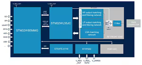
Once the location and condition of the asset have been determined, it’s time to communicate that information. Depending on the circumstances, that can require a combination of long and short-range secure connectivity. In the case of the STEVAL-ASTRA1B multi-connectivity asset tracking platform from STMicroelectronics, connectivity and security are supported by several system elements on the main board, including (Figure 2):
- The STM32WB5MMG is a certified 2.4 GHz wireless module that integrates a STM32WB dual-core Arm® Cortex®-M4/M0+, crystals, and a chip antenna with a matching network. It includes a Bluetooth Low Energy (BLE) stack and supports Open Thread, Zigbee, and other 2.4 GHz protocols.
- The STM32WL55JC provides long-range wireless connectivity. It also includes a dual-core Arm Cortex-M4/M0+ and can support protocols like GFSK, LoRa, and others. The RF front end in the standard version supports the 868, 915, and 920 MHz bands. Changing some components enables the module to support lower frequencies.
- The STSAFE-A110 secure element connects to the STM32WB5MMG for secure data management and authentication. It’s designed to support internet of things (IoT) networks like asset tracking and includes a secure operating system and secure microcontroller.
Asset tracking development environment
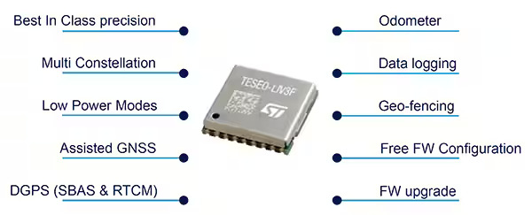
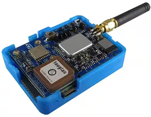
Developers of asset-tracking applications can turn to the STMicroelectronics’ STEVAL-ASTRA1B hardware and software development kit and reference design that facilitates prototyping, testing, and evaluating advanced asset-tracking systems (Figure 3). The STEVAL-ASTRA1B is built around the STM32WB5MMG module and the STM32WL55JC SoC that combine for short and long-range connectivity (BLE, LoRa, and 2.4 GHz and sub-1-GHz proprietary protocols). For NFC connectivity, the ST25DV64K is available. The STSAFE-A110 supports secure operation, and the Teseo-LIV3F GNSS module provides outdoor positioning.
The GNSS positioning receiver is compatible with six systems, including GPS, Galileo, GLONASS, BeiDou, QZSS, and NavIC (also called IRNSS). The system also includes WAAS, EGNOS, MSAS, WAAS, and GAGAN SBASs support. A notch filter is included for anti-jamming.
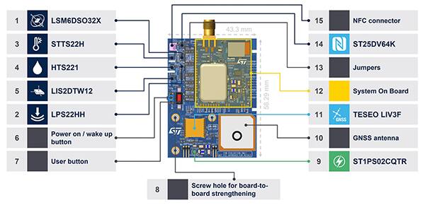
A wide range of sensors are included for condition monitoring, including (Figure 4):
- STTS22HTR – a digital temperature sensor that can be used from -40°C to +125°C with a maximum accuracy of ±0.5°C from -10°C to +60°C and a 16-bit temperature data output. The calibration is NIST traceable, and the device is 100% tested and verified with equipment calibrated per the IATF 16949:2016 standard.
- LPS22HHTR – a MEMS piezoresistive absolute pressure sensor, which is used as a
- digital output barometer that can measure from 260 to 1260 hPa absolute pressure. It features an absolute pressure accuracy of 0.5 hPa and a low-pressure sensor noise of 0.65 Pa, producing a 24-bit pressure data output.
- HTS221TR – a relative humidity and temperature sensor. It can measure 0 to 100% rH with a sensitivity of 0.004% rH/least significant bit (LSB), a humidity accuracy of ±3.5% rH from 20 to +80 % rH, and a temperature accuracy of ±0.5°C from +15°C to +40°C.
- LIS2DTW12TR – a MEMS three-axis linear accelerometer and temperature sensor with user-selectable full scales of ±2g/±4g/±8g/±16g that can measure accelerations with output data rates from 1.6 Hz to 1600 Hz.
- LSM6DSO32XTR – an IMU module that has an always-on 32 g 3D digital accelerometer and a 3D digital gyroscope with ranges of ±4/±8/±16/±32 g full scale and an angular range of ±125/±250/±500/±1000/±2000 degrees per second (dps) full scale.
Power management is important for wireless tracking devices. To ensure long battery life, the STEVAL-ASTRA1B includes extensive power management components like the:
- ST1PS02D1QTR 400 milliampere (mA) synchronous step-down converter with an input voltage range of 1.8 V to 5.5 V, 500 nanoampere (nA) input quiescent current at an input voltage of 3.6 V, and typical efficiency of 92%.
- STBC03JR battery power management and charger IC that includes a linear battery charger section for single-cell lithium-ion (Li-ion) batteries that uses a constant current/constant voltage (CC/CV) charging algorithm, a 150 mA low drop-out regulator (LDO), two single pole double throw (SPDT) load switches and circuitry to protect the battery during fault conditions.
- TCPP01-M12 USB Type-C® port protection IC including VBUS overvoltage protection that’s adjustable from 5 V up to 22 V (with an external N-channel MOSFET), 6.0 V overvoltage protection (OVP) on CC lines against shorting of the VBUS and system-level electrostatic discharge (ESD) protection for connector pins CC1 and CC2 that complies with IEC 61000-4-2 level 4.
Software and firmware libraries
A wide range of software and firmware is included or available for developing asset-tracking applications using the STEVAL-ASTRA1B. Examples include:
- The FP-ATR-ASTRA1 function pack implements a complete asset tracking application and is included with the STEVAL-ASTRA1B. The function pack gets positioning data from the GNSS receiver, reads the data from the environmental and motion sensors, and sends them to the cloud using BLE and LoRaWAN connectivity. Customizable use cases for fleet management, livestock monitoring, goods monitoring, and logistics are included.
- The STAssetTracking application can remotely configure a BLE, Sigfox, or NFC-capable asset-tracking device. It can be used to enable data logging for specific sensors and set threshold triggers to start and stop logging.
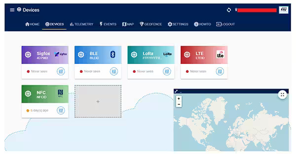
- The DSH-ASSETRACKING dashboard is an Amazon Web Services (AWS) powered cloud application that provides an intuitive interface optimized for collecting, visualizing, and analyzing data from GNSS location services and motion and environmental sensors. The dashboard can plot real-time or historical position data and sensor values and monitor environmental conditions and events (Figure 5).
Summary
Asset tracking is a critical and complex function needed with livestock monitoring, fleet management, and logistics. As shown, the STEVAL-ASTRA1B hardware and software development kit and reference design from STMicroelectronics includes the GNSS location services, a full range of environmental and motion sensors, power management, and a complete range of software and firmware needed to speed the design of high-performance asset tracking devices.